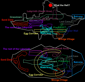
Map of the floating island

Apr 17, 2024 at 7:21 AM
It Really Do Be Like That Sometimes
"Wacka-Wacka-Wacka-Wacka-Wacka-Wacka-Wacka-Wacka-BLEIUP"
Join Date: Aug 10, 2017
Location: Blood Stained Sanctuary
Posts: 340
Age: 21
Pronouns: he/him
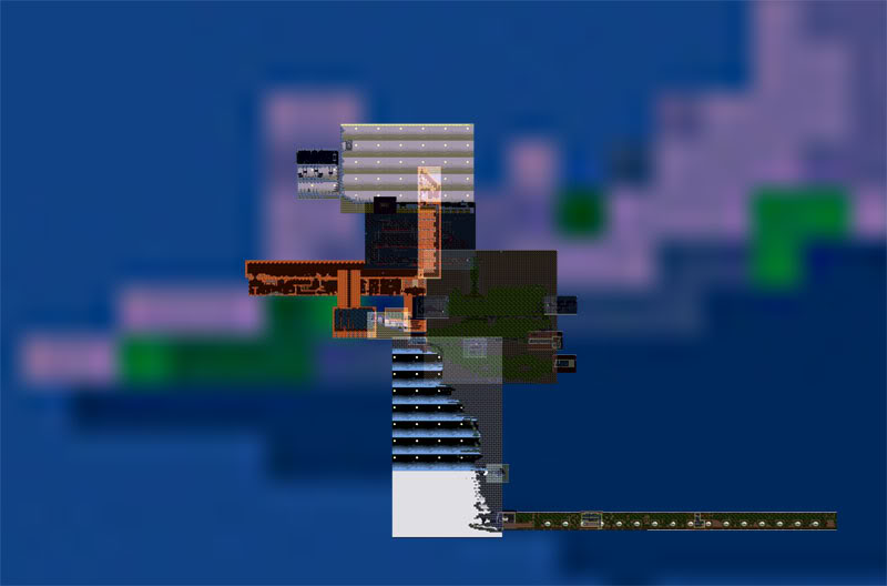
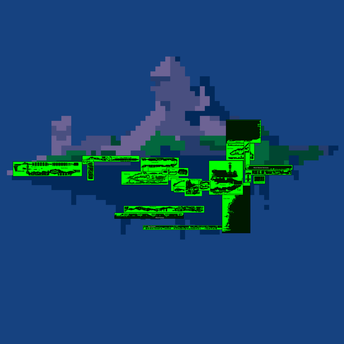
Have you ever wondered what Cave Story's floating island looks like all mapped out? Well, I figure I'd take a stab at it.

To establish where things are in the map, I used an image of the island from Cave Story+. Then I placed my starting point: The outer wall. The outer wall is very useful because we know it's on the east side of the island. From there, I placed the outer wall in the place that made the most sense. (You can compare to the original image of the island) Thankfully, lots of places are connected to the Outer Wall. The Egg Corridor, Plantation, Last Cave, Balcony, and Blood Stained Sanctuary are all physically connected. It's pretty cool how when I lined everything up, the Passage? In the BSS is actually really close to where you can access it in the plantation.

There's another string of connected areas. The whole Labyrinth is connected to the core, which is connected to the waterway which is connected to Mimiga village, which is connected to the first cave. However, we don't know where these places actually are in the island. The only thing I could deduce is that the Core is probably in the center of the island. I mean, it's called the core. So, I put the core in the middle and connected everything else. There's a little gap between the Waterway and Mimiga Village for the place you fight Ironhead in, which goes on infinity depending on how long the fight lasts. Looking at this section, it's pretty cool how the First Cave is actually really close to the core.

That leaves 2 major areas not connected to any others:m Bushlands and Sand Zone. For Bushlands, I had one single half clue: the Wind Fortress. The Wind Fortress obviously takes place in the bottom of the island. And, the place you start looks a lot like Bushlands, so based on that we can guess that Bushlands is close to the bottom of the island. So, I chose the place that would make the most sense for the Wind fortress to go, and put Bushlands above that. That leaves Sand Zone, which really is just a mystery. My only guess is that it's visually brighter than most other areas, so it might be near the top. I ultimately just put it in a place that kinda made sense.

Anyway, here's the map: Screenshot 2024-04-17 at 2.12.15 AM.png
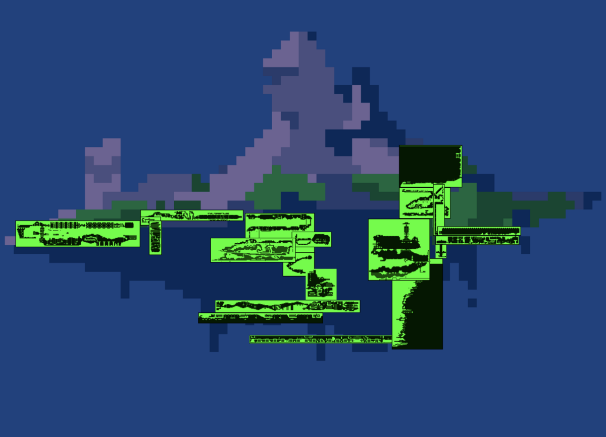
The actual image had to be really big. Despite only being half a megabyte, CSTSF won't let me upload it. The full size image, with locations labeled, is attached as a .zip file.

Obviously, there are some problems. The biggest one is Egg Corridor, it kinda just goes off the edge of the map. Honestly, there's just no where else to put it. You could think of it as being angled on the z axis, but as it stands, this is a pretty big flaw. Other than that, the balcony is a little weird, as it's not on the very edge of the map. I think for this one, you have to think of it having a z axis. Where it is is pretty close to the "mountain" at the top, and that the big wall that you can climb to get xp and hearts is a part of that mountain. And you have to think of the edge as being on the z axis. For example, when Sue and Quote jump off the island at the end of the normal ending, they are jumping towards the "camera" when we look at the island like this. The only other issue is that the Last Cave and Blood Stained sanctuary B1 overlap, but it's not hard to imagine then being in different places on the z-axis.

So, what do you think of the map? Would you have done anything differently?
 

Attachments

Last edited:
Apr 17, 2024 at 10:15 PM
Indie game enthusiast
"What is a man!? A miserable pile of secrets! But enough talk, have at you!"
Join Date: Apr 18, 2006
Location: Forever wandering the tower...!
Posts: 1789
Pronouns: he/him
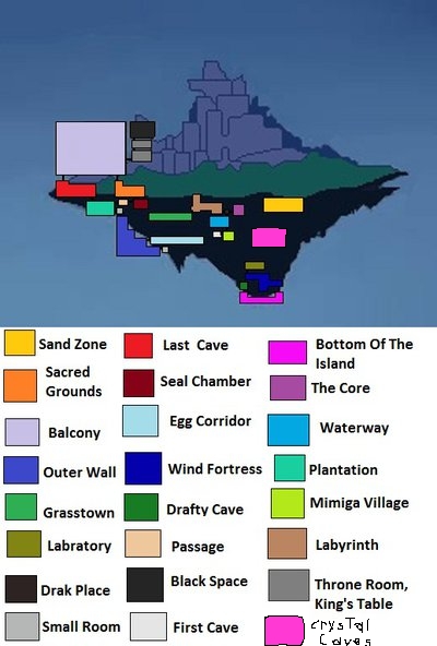
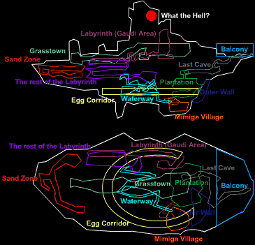
Nice. I always liked seeing various interpretations of the island's layout. Makes you think... Personally I've fixated on the protrusion on the left side of the island. Thinking it was the area where the Balcony takes place.
Here are some older threads with images and discussion too:
cave_story_island__outdated__by_darksamus20-d6euhnh_zps3bf7dd17.jpg


csmap.gif


puzzle1.jpg


screen-shot-2021-12-24-at-1-45-01-pm-png.8109


Since it's a 2D sidescroller, you have to account for the fact that in an actual map of the place, each screen may not lay along the same planes. Each time you go through a door, you don't know what kind of angles you're encountering.

The way I see it, the game is probably full of small corridors, foyers, or what have you that are just skipped because the only purpose is to go from one door to another, and it would be silly to represent it in a screen where you load, walk two tiles, and exit. Any of these unseen places could turn the plane in one direction or the other.

Technically, if you did go straight through one door and out the other side (both maps along the same plane), you'd have to flip the second map, because it's only by convention that we think of "right" on one map as going in the same direction as "right" on the next. But when you think about it, going through a door flips the camera angle.

So it's all really open to interpretation. Unless your setting is naturally linear (like a highway), you'll always have ambiguity when translating from a 2D representation to a 3D map.
 
Apr 18, 2024 at 3:23 AM
Based Member
"Life begins and ends with Nu."
Join Date: Dec 31, 2011
Location: United States
Posts: 2326
Age: 27
Pronouns: he/him
When I first saw this, my immediate thought was that this had already been done before, and I was thinking back on those threads that X-Calibar linked to. But now that I look back at those, I realize that most of them aren't as thorough as yours is, and many of them were from before Wind Fortress debuted in CS+. This is a nice model you have here, I like how you connected the Plantation with the Sacred Grounds, and Grasstown with the Bottom of the Island from the Wind Fortress challenge.

There are still some more maps you could have added here where the map system works, though. Any reason why you didn't add Corridor and Seal Chamber onto the Passage?

And why leave out the Reservoir, Mimiga Graveyard, and Yamashita Farm? I think it would have been cool if you did something to connect the Waterway with the Reservoir, or with the pipes leading to the shore at the Plantation that Curly presumably washed up on, or perhaps to connect all 3 in some areas. Maybe harmonizing all of that would have been kinda tricky, but I feel like that was a missed opportunity.

In any case, this is still some good work mapping this out.
 
Last edited:
Apr 18, 2024 at 4:25 AM
It Really Do Be Like That Sometimes
"Wacka-Wacka-Wacka-Wacka-Wacka-Wacka-Wacka-Wacka-BLEIUP"
Join Date: Aug 10, 2017
Location: Blood Stained Sanctuary
Posts: 340
Age: 21
Pronouns: he/him
There are still some more maps you could have added here where the map system works, though. Any reason why you didn't add Corridor and Seal Chamber onto the Passage?

And why leave out the Reservoir, Mimiga Graveyard, and Yamashita Farm?
Because I was lazy lol. I figured that those areas would be "obvious" and that I didn't need to add them. However, I now realize just how few areas I didn't add, and it just made sense to add them. Interestingly, When I put the Seal Chamber there, I kinda notice that It's not really near the top of the Island, even though Balrog is able to jump from the Seal Chamber out of the Island. However I'm sure it's just a case of having to think in 3D space. Either that or Balrog is just REALLY powerful.

I think it would have been cool if you did something to connect the Waterway with the Reservoir, or with the pipes leading to the shore at the Plantation that Curly presumably washed up on, or perhaps to connect all 3 in some areas. Maybe harmonizing all of that would have been kinda tricky, but I feel like that was a missed opportunity.
The Main issue is the Main Artery, which goes on forever and doesn't have an actual map. (I am only just now realizing that the map for the Main Artery tells you how to get the Ikachan easter egg. Plus, I think it's the only chase of non-HUD English text in the original version of the game. Pretty interesting.) You kinda have to fill in the blanks with that. But, I did rearrange things because I realized I put Mimiga Village in the wrong place relative to First Cave, and the reservoir is kinda sleighed with the waterway. Additionally, the plantation is a straight shot from the waterway, so I'd not too hard to imagine the Main Artery splitting in 2 with one path leading to Mimiga Village and one path leading to the plantation.

Here's the updated map:CaveStoryMap4small.png

And of course the .zip file is there if you want to view it in all of it's 4800x4800 glory
 

Attachments

Apr 19, 2024 at 4:58 PM
World's #1 Laharl Kinnie
"All your forum are belong to us!"
Join Date: Sep 22, 2012
Location: Hell
Posts: 608
Pronouns: She/It
The Main issue is the Main Artery, which goes on forever and doesn't have an actual map
It could just be a closed loop of some kind, at its simplest form it's just a circle around the whole island. The only area it realistically wouldn't be connected to is Sand Zone and maybe Bloodstained Sanctuary because there's no grass in those locations. (Outer wall if anything should have grass due to the heavy presence of clouds making it have to be at least somewhat humid)

Also, where's the Sand Pit and the rest of Wind Fortress? Wind Fortress is a pretty vertical area if you take into account the other parts of it.
 
Apr 19, 2024 at 6:51 PM
Gay AF
"Life begins and ends with Nu."
Join Date: Jun 27, 2013
Location:
Posts: 2822
Age: 29
Pronouns: She/Her
I do think it's possible to maybe give a more cohesive idea for mapping the island out through two factors, alongside laying the levels near each other. That is through the geology of the island, as well as the fauna of the island.

So for geology, obviously this is a floating island, but it seems to have different stone types in both its backgrounds and its tilesets. Now granted, backgrounds like bkBlue or bkGreen are just, the same background, but different colors, and the same can also be said with tilesets like PrtMimi, PrtCave, PrtWhite, and PrtHell. This can actually be pretty helpful with what maps are close to each other or not. I've made lists of the maps with backgrounds and tilesets that could work with this theory. Note: Some maps are excluded due to either terrain being mostly artificial, man-made structures (Egg Corridor, Core) or due to maps being inside buildings and/or part of a much larger map (Arthur's House, Jenka's House, Shelter). Gonna need info on the challenge maps like Wind Fortress, Sand Pit, and Nemesis Challenge (while it's ambiguous for the weapon challenge maps, a section of Nemesis Challenge is used in Cave Story 3D, labeled as "Inner Wall", this will probably be the only CS3D section and weapon challenge map that will be included in the mapping of the island).
Too dark (bkBlack)
Start Point
First Cave
Graveyard
Labyrinth I
Labyrinth H
Camp
Dark Place
Core
Storage
Passage?
Hermit Gunsmith

bkBlue
Mimiga Village
Arthur's House
Grasstown
Reservoir
Main Artery
Labyrinth B
Storehouse
Waterway Cabin
Little House
Statue Chamber
Seal Chamber

bkGreen
Egg Corridor
Sand Zone
Yamashita Farm
Gum
Waterway
Plantation

bkGard
Sand Zone Storehouse
Sacred Grounds - B1
Sacred Grounds - B2
Sacred Grounds - B3

bkMaze
Labyrinth W

bkGray
Boulder Chamber
Last Cave/Last Cave Hidden //Note: While the background is blacked out in-game, the background is very much there if you open it with any editor.

bkRed
Labyrinth M
PrtWeed
Grasstown
Gum

PrtMaze
Labyrinth I
Labyrinth H
Labyrinth W
Camp
Clinic Ruins
Labyrinth B
Boulder Chamber
Labyrinth M

PrtSand
Sand Zone
Sand Zone Residence

PrtMimi
Mimiga Village
Shack
Reservoir
Graveyard
Yamashita Farm
Save Point (Mibox)

PrtCave
First Cave
Start Point
Dark Place
Storage
Hermit Gunsmith

PrtRiver
Main Artery
Waterway

PrtGard
Sand Zone Storehouse

PrtOside
Outer Wall
Clock Room

PrtCent
Plantation

PrtJail
Jail No. 1
Hideout
Rest Area
Last Cave/Last Cave Hidden

PrtWhite
Balcony
Throne Room
Corridor

PrtHell
Sacred Grounds - B1
Sacred Grounds - B2
Sacred Grounds - B3
Statue Chamber
Seal Chamber

As for bestiary/fauna, it's a bit less cohesive than the geology theory, as most maps have unique creatures, I do feel this should still be put up anyway as a supporting factor to the geology theory, as well as the fact that Grasstown and Waterway use the same type of mobs. This will exclude maps are exclusively for NPCs or for Ravils.
NpcEggs1
Egg Corridor

NpcWeed
Grasstown
Gum
Waterway

NpcMaze
Labyrinth I
Labyrinth H
Labyrinth W
Labyrinth Shop
Labyrinth M

NpcSand
Sand Zone
Deserted House

NpcCemet
First Cave
Graveyard
Storage

NpcGuest (Chinfish)
Reservoir

NpcStream
Main Artery

NpcEggs2
Egg Corridor?

NpcMoon
Outer Wall

NpcCent
Plantation
Teleporter
Statue Chamber

NpcRed
Last Cave/Last Cave Hidden

NpcHell
Sacred Grounds - B1
Sacred Grounds - B2
Sacred Grounds - B3
Seal Chamber

PS - use image sharing websites (Imgur/Catbox/Postimg/Gyazo) the next time you update the island map. Saves you the trouble of ever uploading anything to the thread again.
 
Last edited:
Apr 21, 2024 at 4:38 AM
Been here way too long...
"Big Joe Tire and Battery Restaurant! Opening Soon! Eat at Big Joes!"
Join Date: Oct 7, 2013
Location: India
Posts: 514
Neat job! I wouldn't have thought of linking Grasstown with Wind Fortress, good catch there. It's also interesting to put Sand Zone next to the Labyrinth, since that's where Jenka lives and presumably she wanted to stay close to keep watch on the Gaudis and the Core?

I think it would have been cool if you did something to connect the Waterway with the Reservoir, or with the pipes leading to the shore at the Plantation that Curly presumably washed up on, or perhaps to connect all 3 in some areas. Maybe harmonizing all of that would have been kinda tricky, but I feel like that was a missed opportunity.
To be fair, all we know is that these areas are linked by some sort of pipe/sewer system - there's no telling what sort of long or circuitous route exists between them, so I feel like it would be difficult to draw any conclusions here.
Actually, on second thought, I guess we can safely say that at least the Main Artery can't be too far from the Plantation - since Curly did manage to survive that trip without an Air Tank. We didn't even need to drain her again (unless Cthulhu already did, but it's implied draining robots is a very technical skill, so I'm not so sure about that).
 
Apr 28, 2024 at 8:54 AM
Administrator
Forum Administrator
"Life begins and ends with Nu."
Join Date: Jul 15, 2007
Location: Australia
Posts: 6222
Age: 38
Pronouns: he/him
The main issue with island mapping that I tried to fix with my map was that the 2D aspect of this game is a gameplay mechanic. The island would still be a 3D space for mapping purposes. Going through a door from Map A to Map B should mean that Map B is reversed to Map A, because that's simply how doors work. I mean... stand in front of a door and point left. Now walk through the door, turn to face that door, and point left. Notice how you are pointing in a different direction? That applies here. Also even if maps are all in a straight line (I doubt this with regards to Egg Corridor, I suspect it is curved), you need to consider that they might not exist in parallel with each other. The outer wall could be on the front or back face of the island rather than the sides for all we know.
 
Last edited:
Apr 29, 2024 at 5:53 PM
It Really Do Be Like That Sometimes
"Wacka-Wacka-Wacka-Wacka-Wacka-Wacka-Wacka-Wacka-BLEIUP"
Join Date: Aug 10, 2017
Location: Blood Stained Sanctuary
Posts: 340
Age: 21
Pronouns: he/him
The main issue with island mapping that I tried to fix with my map was that the 2D aspect of this game is a gameplay mechanic. The island would still be a 3D space for mapping purposes. Going through a door from Map A to Map B should mean that Map B is reversed to Map A, because that's simply how doors work. I mean... stand in front of a door and point left. Now walk through the door, turn to face that door, and point left. Notice how you are pointing in a different direction? That applies here.
Wow, I never thought about it that way
 
Apr 30, 2024 at 2:36 AM
ZYZZ Spur is the best gun because its super cool
"All your forum are belong to us!"
Join Date: Jan 15, 2017
Location: Northern Hemisphere
Posts: 565
Age: 16
Pronouns: he/him
i like this and i like water way
but yeah egg corridor is a little weird idk where it would go
 
Apr 30, 2024 at 7:53 AM
Administrator
Forum Administrator
"Life begins and ends with Nu."
Join Date: Jul 15, 2007
Location: Australia
Posts: 6222
Age: 38
Pronouns: he/him
i like this and i like water way
but yeah egg corridor is a little weird idk where it would go
As I was saying earlier... if the egg corridor was one big circular corridor (where the start and end of the egg corridor almost touch) then it would occupy only a third of the width that it would in a straight line.
 
May 1, 2024 at 3:54 AM
Gay AF
"Life begins and ends with Nu."
Join Date: Jun 27, 2013
Location:
Posts: 2822
Age: 29
Pronouns: She/Her
Tbf, a circular egg corridor would make a lot of sense, especially with the area already being curved in CS3D.
 
Back
Top